|
The 2004 Tsunami took the lives of 230,000 coastal residents in Asia, but mangrove forests saved thousands more.
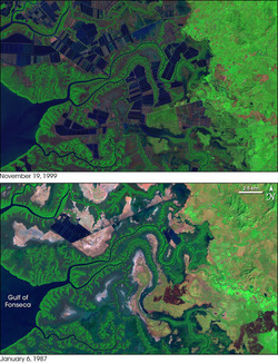
Chandra Giri, a land change scientist with the U.S. Geological Survey, was intrigued. “I watched TV news reports six years ago showing lives and property saved by mangroves during the tsunami,” said Giri. “These trees really do have a role to play as a protective barrier against some natural disasters.” Mangroves, or salt-tolerant coastal forests, provide food, habitat and carbon storage, but their ability to safeguard against hurricanes, tsunamis and floods is less clear. Giri set out to assess the protective value of mangrove forests, but a lack of distribution data sent his team of international scientists looking at where mangrove forests are rather than what they do. The team’s high-resolution satellite-based map of global mangrove distribution, which was published in the Journal of Global Ecology and Biogeography this summer, is the first of its kind. It shows mangroves on about 53,000 square miles of earth’s surface—12 percent less than previously thought. This reduction, coupled with increasing threats to mangroves, is cause for conservation concern. According to Giri, “Thirty five percent of mangrove ecosystems disappeared between 1980 and 2000…due to agricultural expansion, urban development and shrimp farming.” Source: http://www.eurekalert.org/pub_releases/2010-10/nsfc-rot102810.php
2 Comments
5/14/2014 03:27:29 pm
Thank you for the sensible critique. Me & my cousin were just preparing to do some research on this. We grabbed a book from our location library but I believe I learned far more from this post. I'm quite glad to see such amazing info being shared freely out there…
Reply
Leave a Reply. |
with intentions.
|

 RSS Feed
